 |
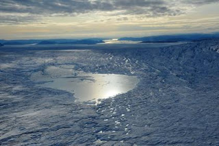
| Supraglacial lake on greenland ice sheet (colorado.edu) |
A study conducted by the University of Colorado Boulder-based Cooperative Institute for Research in Environmental Sciences stated that the Greenland ice sheet can slide quickly into the sea. This is because a large amount of melt water occurs from the surface of the lake.
Such lake drainages may affect sea-level rise, with implications for coastal communities, according to the researchers. “This is the first evidence that Greenland’s ‘supraglacial’ lakes have responded to recent increases in surface meltwater production by draining more frequently, as opposed to growing in size,” says CIRES research associate William Colgan, who co-led the new study with CU-Boulder computer science doctoral student Yu-Li Liang.
During summer, meltwater pools into lakes on the ice sheet’s surface. When the water pressure gets high enough, the ice fractures beneath the lake, forming a vertical drainpipe, and “a huge burst of water quickly pulses through to the bed of the ice sheet,” Colgan said.
By using satellite imagery that comes with innovative features of the software, to monitor nearly 1,000 lakes on the ice sheet with an area Connecticut-sized for 10 years. They discovered that as the climate warms, such catastrophic lake drainages are increasing in frequency. Catastrophic lake drainages were 3.5 times more likely to occur during the warmest years than the coldest years.
During a typical catastrophic lake drainage, about 1 million cubic meters of meltwater -- which is equivalent to the volume of about 4,000 Olympic swimming pools -- funnels to the ice sheet’s underside within a day or two. Once the water reaches the ice sheet’s belly that abuts underlying rock, it may turn the ice-bed surface into a Slip ’N Slide, lubricating the ice sheet’s glide into the ocean. This would accelerate the sea-level rise associated with climate change.
Alternatively, however, the lake drainages may carve out sub-glacial “sewers” to efficiently route water to the ocean. “This would drain the ice sheet’s water, making less water available for ice-sheet sliding,” Colgan said. That would slow the ice sheet’s migration into the ocean and decelerate sea-level rise.
“Lake drainages are a wild card in terms of whether they enhance or decrease the ice sheet’s slide,” Colgan said. Finding out which scenario is correct is a pressing question for climate models and for communities preparing for sea-level change, he said.
For the study, the researchers developed new feature-recognition software capable of identifying supraglacial lakes in satellite images and determining their size and when they appear and disappear. “Previously, much of this had to be double-checked manually,” Colgan said. “Now we feed the images into the code, and the program can recognize whether a feature is a lake or not, with high confidence and no manual intervention.”
The researchers have already to manually verify the accuracy of the program with about 30 percent of the image to see more than 30 percent of the study area. They found that the algorithm - a procedure step-by-step for calculating - correctly detected and tracked 99 percent of supraglacial lakes.
The program can be useful in future studies to determine how the lake affects the drainage of sea level rise, according to researchers. CIRES co-authors on the team including Konrad Steffen, Waleed Abdalati, Julienne Stroeve and Nicolas Bayou.
This story has edited by author of threelas
Source: University of Colorado Boulder
Publication: Sciencedirect
Post a Comment